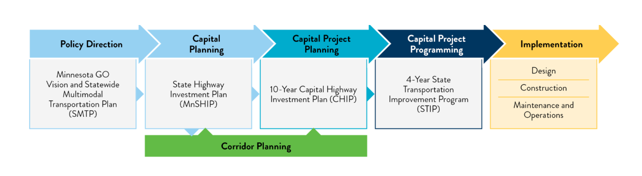
Corridor Planning at MnDOT
MnDOT is expanding and enhancing its corridor planning practice. We are developing new tools to promote plan consistency, increasing planning staff capacity statewide, and programming $3 million annually to support statewide corridor planning activities.
MnDOT is developing a Corridor Planning Guidebook to support the preparation of corridor plans. This tool will guide the planning process to support consistent evaluations on State highways and alignment with statewide transportation goals. The Corridor Planning Guidebook is for use by practitioners statewide who are preparing plans for State highways.
Another tool in development is the Corridor Planning Prioritization process. Learn more about this parallel effort here: MnDOT Corridor Planning Prioritization Process
Corridor Planning is a strategic and thorough approach to analyzing and designing transportation systems in a specific area, and centers statewide transportation goals in developing and advancing the transportation system.
- Strengthen the link between the state’s transportation goals and MnDOT’s statewide plans and project investments, including the Statewide Multimodal Transportation Plan (SMTP) objectives.
- Help MnDOT prioritize resources in locations with the greatest opportunity to advance state transportation goals.
- Help MnDOT and local partners identify transportation goals and community priorities in advance of future projects and funding opportunities.
- Create opportunity for proactive partnership between MnDOT and locals. Community and partner engagement improves plan outcomes and increases community support for resulting improvements.
- Streamline project delivery by identifying transportation goals and community priorities well before project scopes and budgets are set.
Corridor planning typically takes place during Capital Project Planning (7-10 years from project construction) or Capital Planning (10-20 years from project construction). Planning could take place sooner or later depending on the nature of the corridor, and the Corridor Planning Guidebook will strive to be flexible based on various contexts. A different level of detail in a plan is necessary for different plan types.
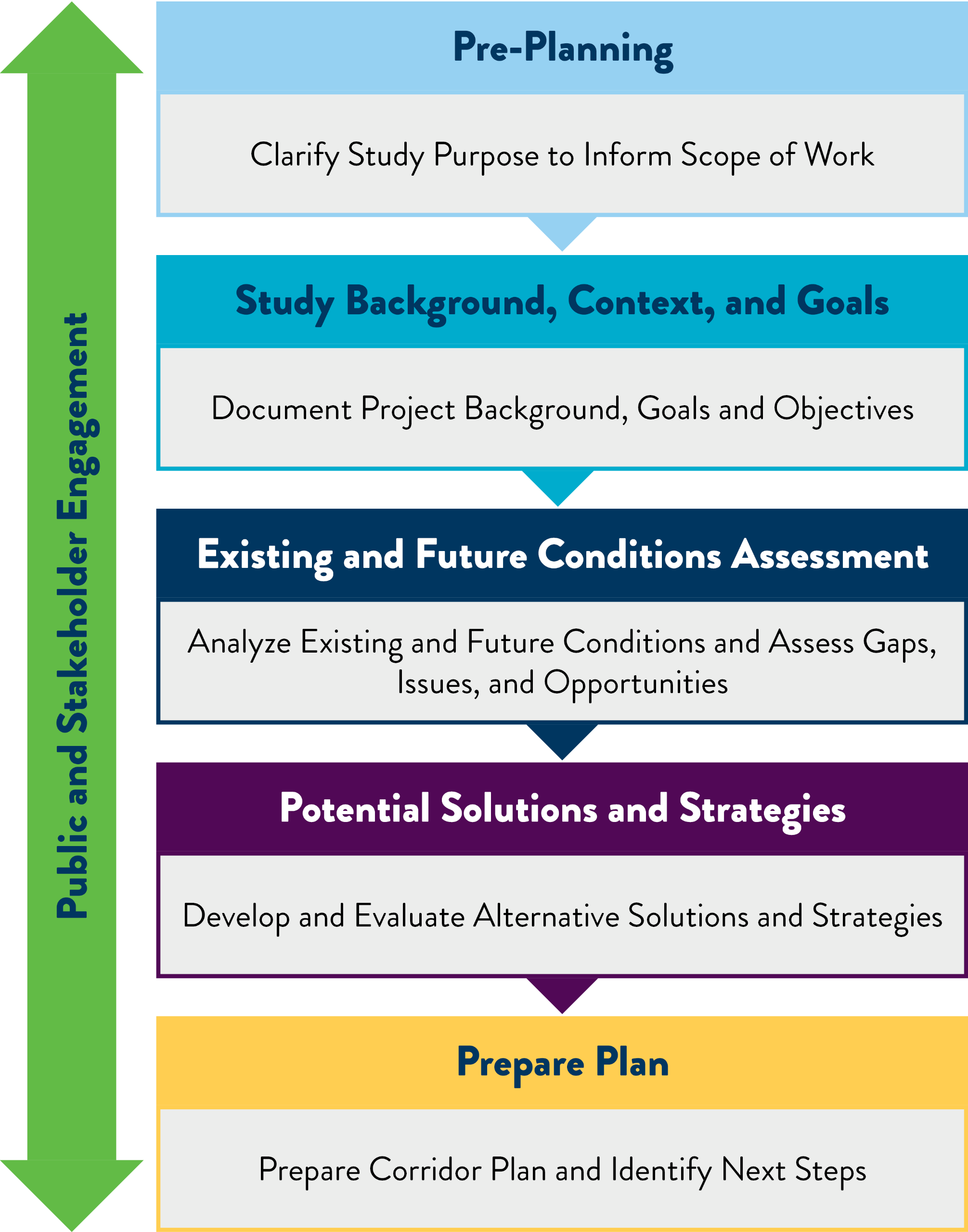
Corridor Planning Guidebook
The Corridor Planning Guidebook outlines the following steps to corridor planning.

- Where is the study being conducted (corridor location, end points, length)?
- Write a brief description of known physical features and adjacent land use.
- What are the key issues or needs that triggered the decision to fund a study? (This may reference the Corridor Planning Prioritization process.)
- Are there any previous relevant studies? Any projects, decisions, or other priorities identified by others?
- Identify any known stakeholders who should be included.
- What is the estimated or target study duration? Are there any schedule drivers?

This step builds on Step 1 and further documents background information to understand context and develop goals and objectives. In many cases, Step 2 will be the starting point of consultant work. Key information to review includes:
- Prior efforts (studies, plans, policies, projects)
- Context (community development, corridor function, demographics)
- Characteristics (context zones, roadway design and modal elements, etc.)

This step is the analysis of existing and future conditions to assess gaps, issues, and opportunities. This is where the team is focusing effort in the development of the Corridor Planning Guidebook right now, and there is more information below in the Existing Conditions Topic Guidance section below.

This step is about the development and evaluation of strategies and solutions to address needs and issues identified in Step 3. The Corridor Planning Guidebook will include recommended evaluation criteria, metrics, and methodology, and guidance on how to frame recommended solutions for short-term and long-term phasing, or fiscally constrained and unconstrained phasing.

This step consists of preparing a Corridor Plan Document that includes recommendations and implementation steps. This will include guidance on how to describe the process necessary to implement the plan, broach funding discussions as appropriate, and could include supportive actions for partner agencies to implement.
Existing Conditions Topic Guidance
Corridor planning is an opportunity to bridge the objectives
identified in the Statewide Multimodal Transportation Plan with MnDOT’s
project development. The Corridor Planning Guidebook provides guidance to help
practitioners evaluate locations through the lens of each SMTP objective. The
sections below outline how the exiting conditions analysis in a planning
process will consider each SMTP objective.
| Documented Crashes | Critical index for fatal and serious injury crashes and all crashes, presence on ped/bike high-injury network, concerning crash patterns |
| Crash Risk | Based on District Safety Plan Risk assessment, other methods as appropriate |
| Asset Condition | Condition of bridges, pavement, traffic signals, and other ancillary assets (culverts, overhead signs, noise walls, etc.) |
| ADA Compliance | Compliance of pedestrian curb ramps, landings, push buttons, etc., with Public Right-of-Way Accessibility Guidelines and MnDOT design standards |
| Maintenance Issues | Maintenance needs or concerns in corridor, based on input from MnDOT maintenance staff |
| Public Utilities | Locations of private and public utilities in the Right-of-Way; understanding of future utility needs/plans if available |
| Contaminated Materials | Areas of known or suspected contamination (soil, groundwater, soil vapor, etc.) within Right-of-Way and adjacent properties |
| Environmental Justice | Presence of minority and low-income populations |
| Historic and Cultural Resources | Known or suspected locations of historic and cultural resources |
| Section 4(f)/6(f) Resources | Identify 4(f) and 6(f) Land and Water Conservation properties adjacent and near the corridor |
| Threatened and Endangered Species | Identify species that are federally- or state-listed as threatened and endangered with habitats in the corridor area |
| Wetlands and Water Resources | Identify boundaries of wetlands and other water resources such as floodplains, streams, etc. |
| Greenhouse Gas (GHG) Emissions | Estimate GHG emissions and opportunities for mitigation |
| Resilience | Assess system and asset vulnerability/protection against major climate events such as flooding |
| Electric Vehicle (EV) Charging | Availability and planned availability of EV charging along corridor; understanding of current and forecasted EV charging demand |
| Access Management | Number and spacing of access points relative to MnDOT Access Management Guidelines |
| Travel Delay | Vehicle level of service and delay at intersections |
| Travel Time Reliability | Variability in travel time along corridor |
| Truck Travel Time Reliability | Variability in travel time along corridor for commercial vehicles |
| Transportation Systems Management and Operations (TSMO) | Presence of existing or planned TSMO features or strategies |
| Freight and Intermodal | Understanding of whether corridor is a freight route (including tonnage), known bottlenecks, rail crossings |
| Job Accessibility by Car | Number of jobs accessible within 30 minutes of driving |
| Facilities and Services | Number and spacing of access points relative to MnDOT Access Management Guidelines |
| Pedestrian Access and Mobility | Pedestrian travel characteristics and quality of connections to destinations |
| Bicyclist Access and Mobility | Bicyclist travel characteristics and quality of connections to destinations |
| Transit and Micromobility | Transit and micromobility rideshare (including electric scooters and bikes) characteristics (including ridership) and quality of connections to destinations |
| Job Accessibility by Bicycle and Transit | Number of jobs accessible within 30 minutes by bicycle (on medium stress roads) and by transit |
| Agricultural Vehicles | Travel patterns and volume of agricultural vehicles |
| Animal-Powered Vehicles | Travel patterns and volume of animal-powered vehicles (horse and buggy or similar) |
| Economic Development and Jobs | Understanding of key businesses and industries, existing and forecasted jobs in the area, partnerships with private sector |
| Tourism | Proximity to state/national parks and trails, other tourism drivers (arts and culture, farm and garden, festivals, events, sports, outdoor recreation) |
| Snowmobiles and Off-Highway Vehicles (OHVs) | Use of corridor by snowmobiles and OHVs (which includes all-terrain vehicles (ATVs)), including on-road use, crossings, and adjacent facilities. |
This SMTP Objective is cross-cutting and will be integrated into every topic and step of the planning process. As an example, Corridor Planning Guidebook users will be asked to consider these questions related to Healthy Equitable Communities when completing a safety analysis:
- Are corridor crashes more common in areas that are home to people who have been historically underserved?
- Are there disproportionate safety risks for people who walk, use a mobility device, bike, or use other means of non-motorized travel?
- Are there safety issues present that prevent roadway users form shifting from motorized to non-motorized modes?
- Are there traffic safety issues that discourage people from visiting businesses and other destinations along the corridor?
This SMTP Objective is cross-cutting and will be integrated into every topic and step of the planning process. People familiar with the study corridor can provide a depth of understanding that is not always captured in safety data or technical analysis alone. As an example, Corridor Planning Guidebook users will be asked to discuss these questions with stakeholders when completing a safety analysis:
- Questions to ask Local Agency Staff:
- Which intersections are known to have recurring safety issues? Who is most impacted by them?
- Which segments are known to have recurring safety issues? Who is most impacted by them?
- If you are someone who travels along this corridor, what concerns you when it comes to safety?
- Do community members let you know about safety concerns along this corridor? If so, where, and what issues are they experiencing?
- Who might have safety concerns that you are not hearing from?
- Are there locations where motorist travel speeds feel unsafe for the context? Locations where travel speeds change?
- Questions to ask the General Public and Other Stakeholders
- Have you been involved in a crash or had a near-miss along this corridor?
- Do you know anyone who has been involved in a crash along this corridor?
- How safe do you feel when driving this corridor compared to others in the area?
- How safe do you feel when walking or biking along this corridor? What about crossing this corridor?
- What would make you feel safer while traveling through or across this corridor?
- Are there locations where motorist travel speeds feel unsafe for the context? Locations where travel speeds change?


